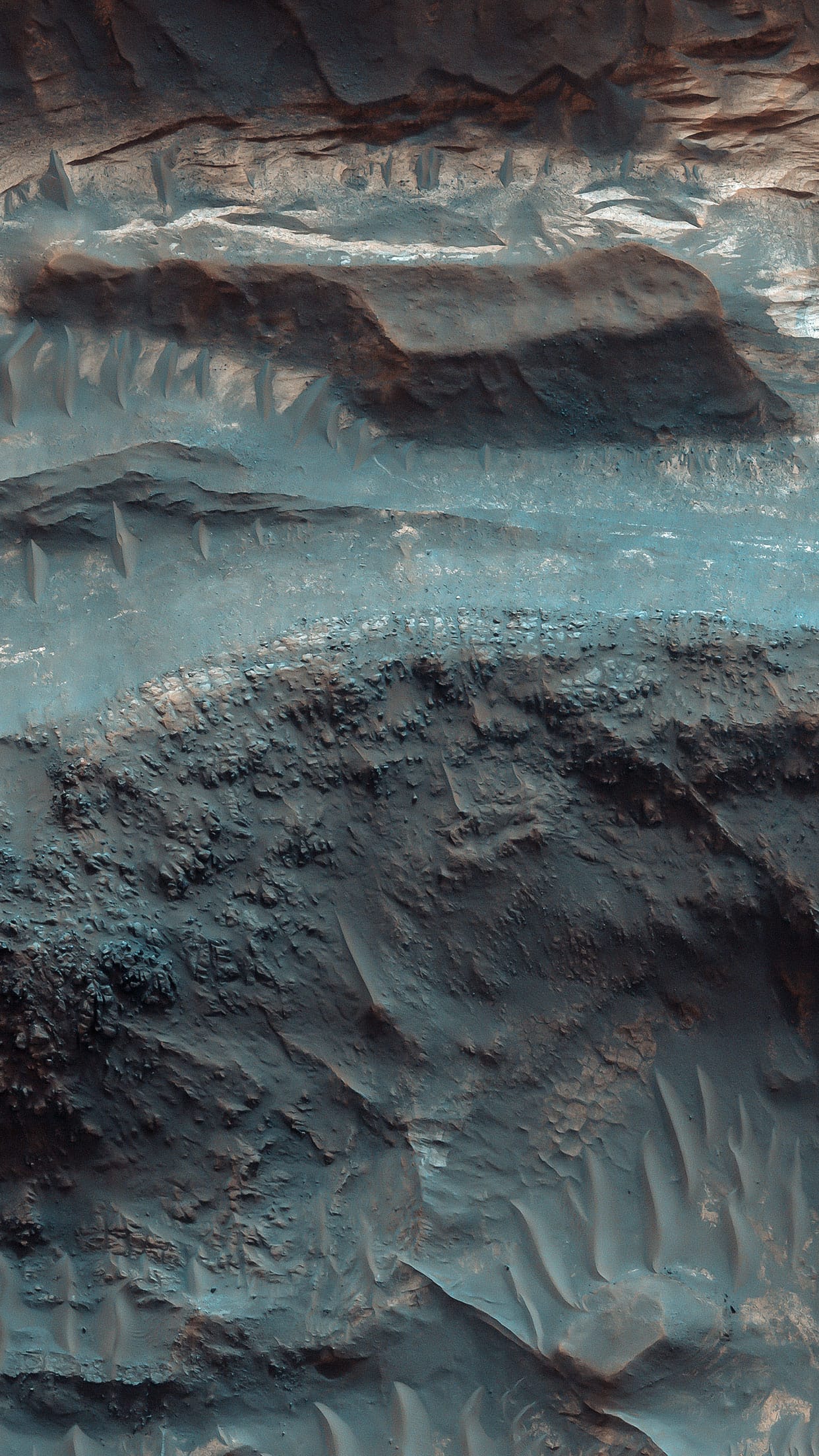
#10 deep space

New infrared view of the Horsehead Nebula.
Deep Space — Psiu Puxa Space Wallpapers
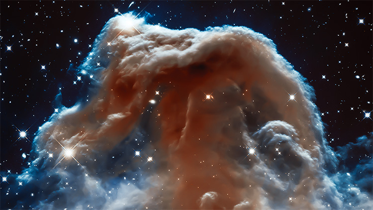
This new Hubble image, captured and released to celebrate the telescope’s 23rd year in orbit, shows part of the sky in the constellation of Orion (The Hunter). Rising like a giant seahorse from turbulent waves of dust and gas is the Horsehead Nebula, otherwise known as Barnard 33.

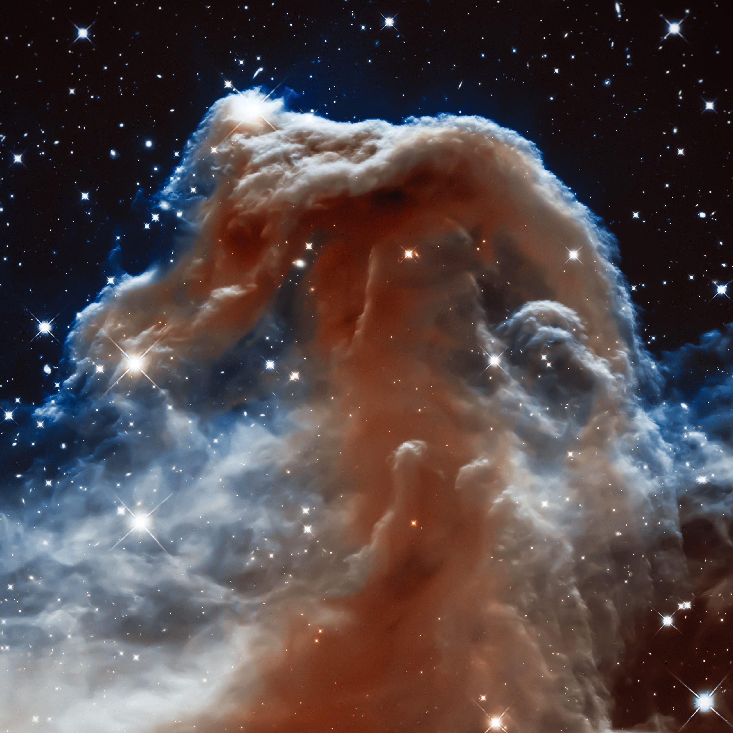
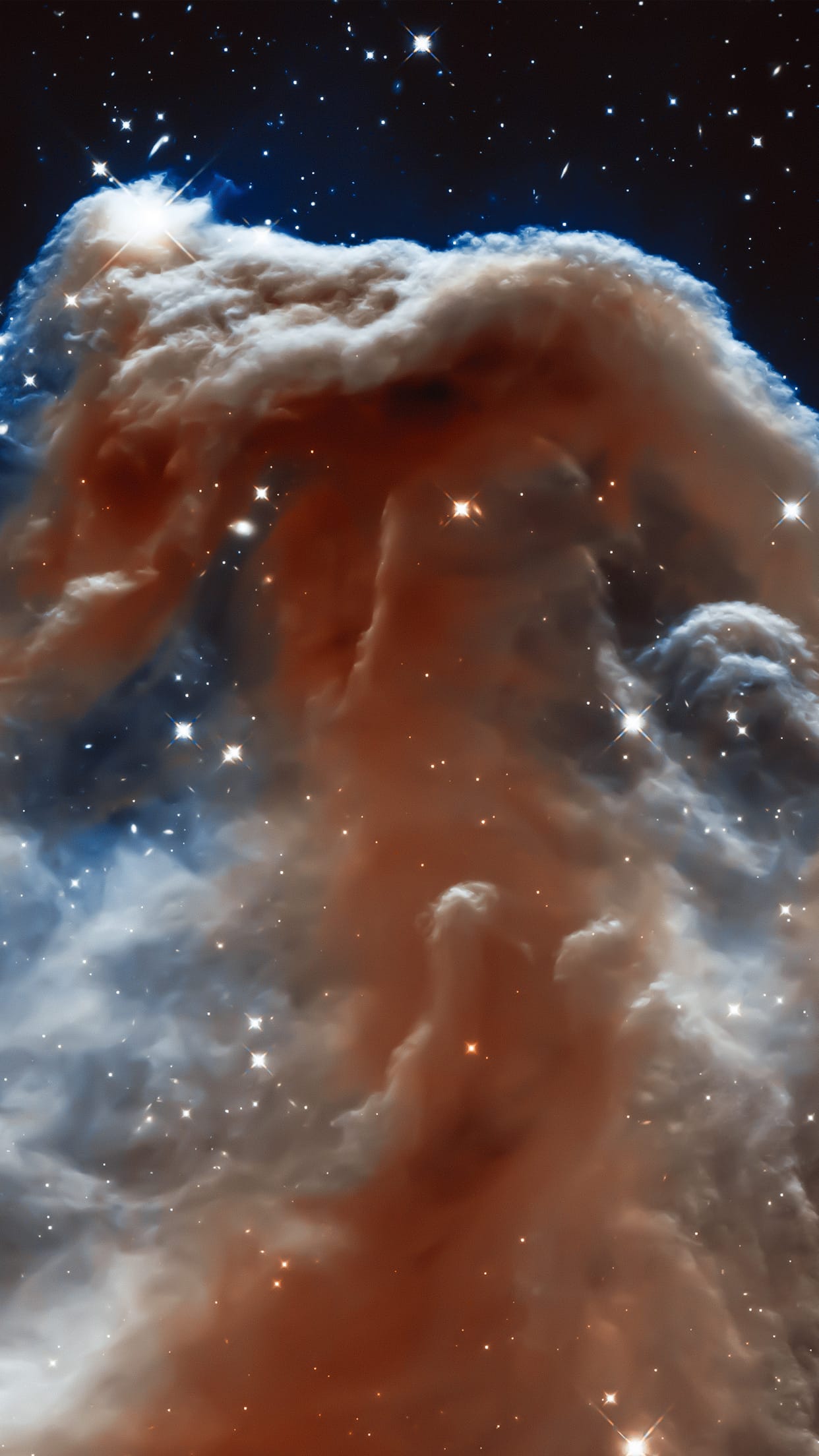
This image shows the region in infrared light, which has longer wavelengths than visible light and can pierce through the dusty material that usually obscures the nebula’s inner regions. The result is a rather ethereal and fragile-looking structure, made of delicate folds of gas — very different to the nebula’s appearance in visible light.

Credit: NASA, ESA, and the Hubble Heritage Team (AURA/STScI)

#9 MARTIAN TERRAIN

Polar Geology.
Martian Terrain — Psiu Puxa Space Wallpapers
Sawtooth Pattern in Carbon Dioxide Ice.

#8 MARTIAN TERRAIN

Volcanic Processes.
Martian Terrain — Psiu Puxa Space Wallpapers
This image reveals the meter-scale surface textures of mesas and knobs in the Aureum Chaos region of Mars.

Aureum Chaos is a wide region of plateaus, mesas, and knobs. Most of the rocks in this area appear to have formed originally as laterally continuous layers through volcanic or sedimentary processes. Loss of groundwater or ground ice could have then caused the ground to collapse, forming the network of deep valleys and isolated hills we see today. Subtle layering of these rocks can be observed along many slope faces jutting out from under a mantle of surface sediments.

Also present along many slopes are dark-toned, discontinuous lineations. These are tracks left behind by boulders that rolled down the slopes. These boulders are often located at the down hill end of the tracks.

Written by: Chris Okubo

#7 MARTIAN TERRAIN

Light-Toned Layering in Noctis Labyrinthus Pit.
Martian Terrain — Psiu Puxa Space Wallpapers
The full image to the east shows shows good exposures of light-toned layering. Scientists want to learn how this layering occurred during the distant past: could it have been water or some other kind of geologic activity?

Just like on Earth, rock layers can tell the geologic history of a region: it's a window to the past. Further study of layering on Mars, and in this region, can help us determine what minerals might be in those layers, including clays and sulfates. By identifying those possible minerals, we start to have a better idea of what deposited them there.

Noctis Labyrinthus is located between the Tharsis upland and Valles Marineris, which is the largest canyon in the Solar System.

Written by: HiRISE Science Team

#6 MARTIAN TERRAIN

Fall Frost Accumulation on Russell Crater Dunes.
Martian Terrain — Psiu Puxa Space Wallpapers
Russell Crater dunes are a favorite target for HiRISE images not only because of their incredible beauty, but for how we can measure the accumulation of frost year after year in the fall, and its disappearance in the spring.

The frost is, of course, carbon dioxide ice that often sublimates (going directly from a solid to a gas) during the Martian spring. HiRISE takes images of the same areas on Mars in order to study seasonal changes like this. In an area like Russell Crater--a very ancient impact crater about 140 kilometers in diameter--we can follow changes in the terrain by comparing images taken at different times. This helps give us a better understanding of active processes on the Red Planet.

Written by: HiRISE Science Team

#5 MARTIAN TERRAIN

Layers, Bedrock Ridges, and Dark Sand in Schiaparelli Crater.
Martian Terrain — Psiu Puxa Space Wallpapers
Like any diverse group of explorers, scientists on the HiRISE team and the general public who submit target suggestions have different goals and interests for the Mars images they hope to get. More often than not, an image intended for one particular science investigation ends up having many other applications, answering and raising new questions.

This image was targeted to look at potential changes in the distribution of dark sand compared to earlier pictures (PSP_005897_1790 three Mars years ago and ESP_016406_1790/ESP_017118_1790, approximately 1.5 Mars years ago). In a preliminary investigation, no such changes have been found, although we will keep looking.

Originally, this area—a crater within the larger Schiaparelli Crater—was targeted to investigate the circumferential layers that fill the crater, evidence for possible past deposition from airfall dust or even water. In this image, we note something that becomes apparent if we zoom in to many of the areas containing dark sand. Here, the sand is on top of periodic bedrock edges oriented semi-radially from the crater and approximately perpendicular to the layers. How did these ridges form, and what is the relationship to the sand?

The ridge origin is a mystery, but the sand may simply be nucleating on the ridges. This suggests that some apparent large ripples on Mars are sand nucleation sites on pre-existing topography. The extent of such ridges, and their relationship to sand elsewhere on the planet, can be further understood with future HiRISE images in other areas.

Written by: Nathan Bridges

#4 MARTIAN TERRAIN

Finding Faults in Melas Chasma.
Martian Terrain — Psiu Puxa Space Wallpapers
Melas Chasma is part of the Valles Marineris canyon system, the largest canyon in the Solar System. It has been recently suggested that Melas Chasma may have been produced by an impact crater. To test this idea, HiRISE has been imaging surrounding small faults such as the ones seen in this image.

There are actually three faults in this image. The two trench-like features are called “graben” and are caused when the surface stretches apart and blocks of rock drop downwards. The third fault is the wavy ridge the cuts across both of the graben. This type of fault is sometimes called a “wrinkle ridge” and occurs when surface rocks are compressed causing one block of rock to be thrust up on top of another. So this area has been both stretched in the north-south direction and squeezed in the east-west direction.

With enough HiRISE images scientists hope to reconstruct the full history of this area and uncover the origin of one of Mars’ most spectacular features.

Written by: HiRISE Science Team

#3 MARTIAN TERRAIN

Fluvial Processes.
Martian Terrain — Psiu Puxa Space Wallpapers
The dark branched features in the floor of Antoniadi Crater look like giant ferns, or fern casts. However, these ferns would be several miles in size and are composed of rough rocky materials.

A more likely hypothesis is that this represents a channel network that now stands in inverted relief. The channels may have been lined or filled by indurated materials, making the channel fill more resistant to erosion by the wind than surrounding materials. After probably billions of years of wind erosion the resistant channels are now relatively high-standing. The material between the branched ridges has a fracture pattern and color similar to deposits elsewhere on Mars that are known to be rich in hydrated minerals such as clays.

The inverted channels have short, stubby branches characteristic of formation by groundwater sapping. Spring water seeps into the channels and undercuts overlying layers which collapse, so the channels grow headward. These images tell the story of an ancient wet environment on Mars, where life could have been possible. Ancient Martian life was most likely to consist of microorganisms rather than giant tree ferns.

Written by: Alfred McEwen

#2 MARTIAN TERRAIN

Megabreccia in the Central Uplift of Stokes Crater.
Martian Terrain — Psiu Puxa Space Wallpapers
Stokes is a large, approximately 60 kilometer diameter (38 miles) impact crater located in the Northern lowland plains of Mars.

Craters this large invariably have a central structural uplift, which form mountain peaks in or near the center of the crater. The Northern plains are largely covered by lavas and sediments, but craters such as Stokes allow us to observe the otherwise buried bedrock, exposed within its central uplift.

Megabreccia, consisting of very large fragments of pre-existing bedrock, is created by energetic processes, but especially by impact events on Mars. Although megabreccia deposits can coat central uplifts, it may not have been the Stokes impact that made this megabreccia.

The formation of a crater's central uplift does not commonly break up and jumble the deep bedrock. So if these megabreccias are exposures of the deep bedrock brought up to the surface by the central uplift, and are not merely deposits draped on the central uplift, then it is most likely that these megabreccias were created by much larger and older basin-forming impacts that now lie buried beneath the surface.

With the aid of high-resolution images, and especially the 3D anaglyphs, we hope to decipher whether the materials observed in the central uplift were formed by the host crater or prior to the formation of that crater. Either way, crater central uplifts can provide windows into the deepest and oldest geologic history of Mars. For example, if there was a very ancient ocean in the Northern lowlands, these rocks could include deposits from that ocean.

Written by: Alfred McEwen

#1 MARTIAN TERRAIN

Sedimentary / Layering Processes.
Martian Terrain — Psiu Puxa Space Wallpapers
This image from the Gordii Dorsum region of Mars shows a large area covered with polygonal ridges in an almost geometric pattern. The ridges may have originally been dunes which hardened (indurated) through the action of an unknown process. Groundwater might have been involved.

Written by: Nicolas Thomas  
All original images are presented by:
547d825dd0db3b8058acab8d_nasa.png 547d828239b0bf7409a305d1_arizona.png 547d828cd0db3b8058acab91_esa.png 547d832bd0db3b8058acab97_hubble.png 547d83369e4d1e7609d4c35d_jpl.png