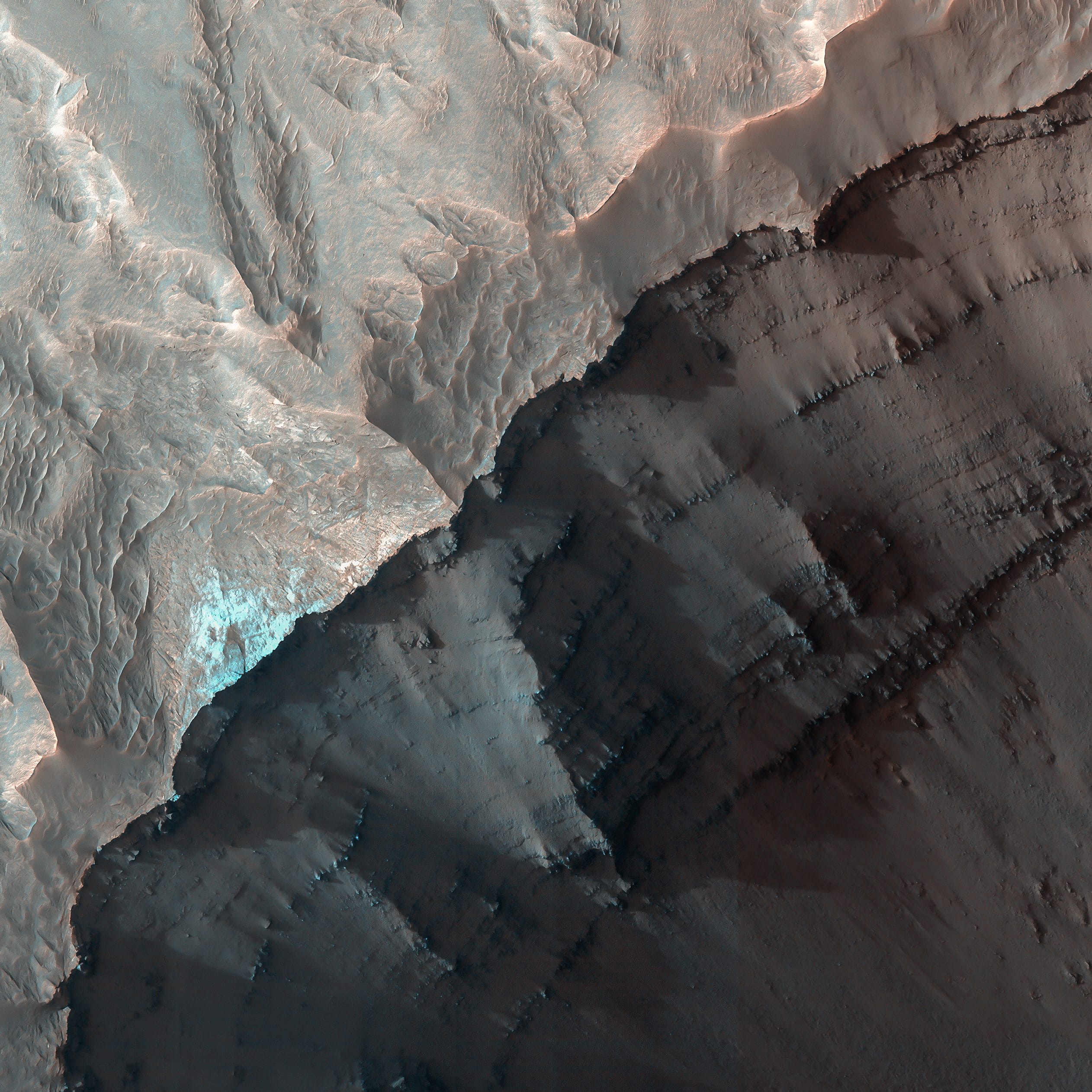
#70 MARTIAN TERRAIN

Impact Processes.
Martian Terrain — Psiu Puxa Space Wallpapers
Fresh Crater Chain in Meridiani Planum.

#69 MARTIAN TERRAIN

Layering at Ganges Chasma.
Martian Terrain — Psiu Puxa Space Wallpapers
This image shows the geologic contact between the walls of Ganges Chasma and the adjacent plains. Ganges Chasma is one of several deep troughs that make up the Valles Marineris system on Mars.

The upper slopes of the walls of Ganges have layering that appears dark, rough, and blocky, consistent with lava flows that are thought to make up the plains around Valles Marineris. Outside of Ganges on the plains is an unusual deposit that appears bright and is eroding back from the walls of Ganges, indicating the deposit isn't as resistant to erosion by the wind as the underlying lava flows.

The bright deposit is mantled by aeolian debris and dust, but along cliffs where erosion has exposed fresher surfaces, one can see meter-scale layering that appears smoother and brighter than the layering visible in the underlying lava flows. Some scientists interpret the layers in this deposit to be sediments laid down by water activity from a channel system located to the west, but explosive volcanism and aeolian airfall can also produce this fine-scale layering.

Written by: Cathy Weitz

#68 MARTIAN TERRAIN

Composition and Photometry.
Martian Terrain — Psiu Puxa Space Wallpapers
Tyrrhena Terra Crater with Central Uplift and Hydrated Minerals.

#67 deep space

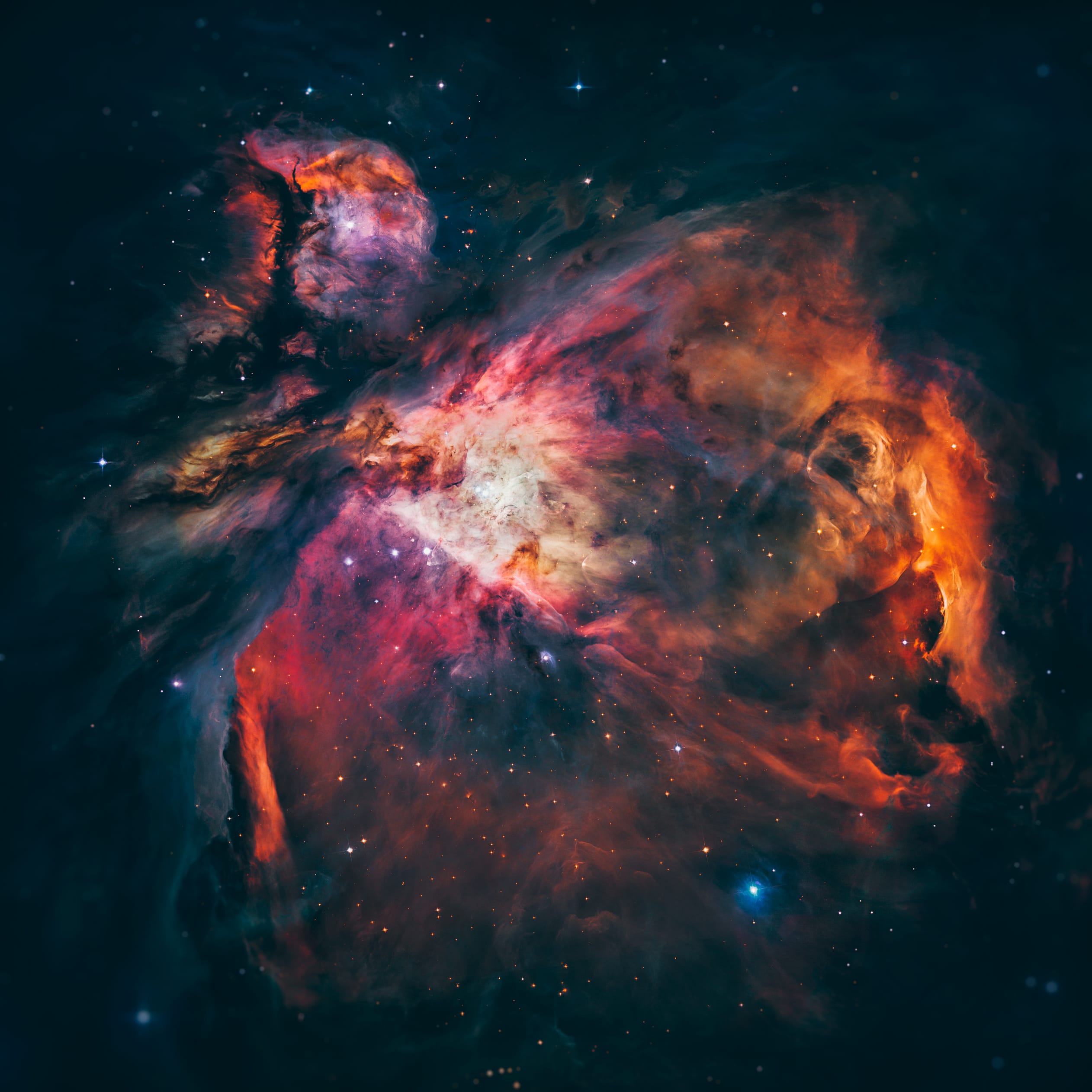
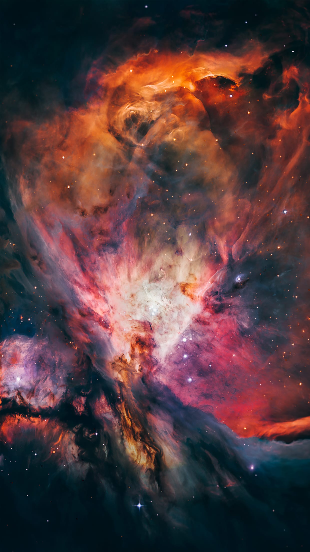
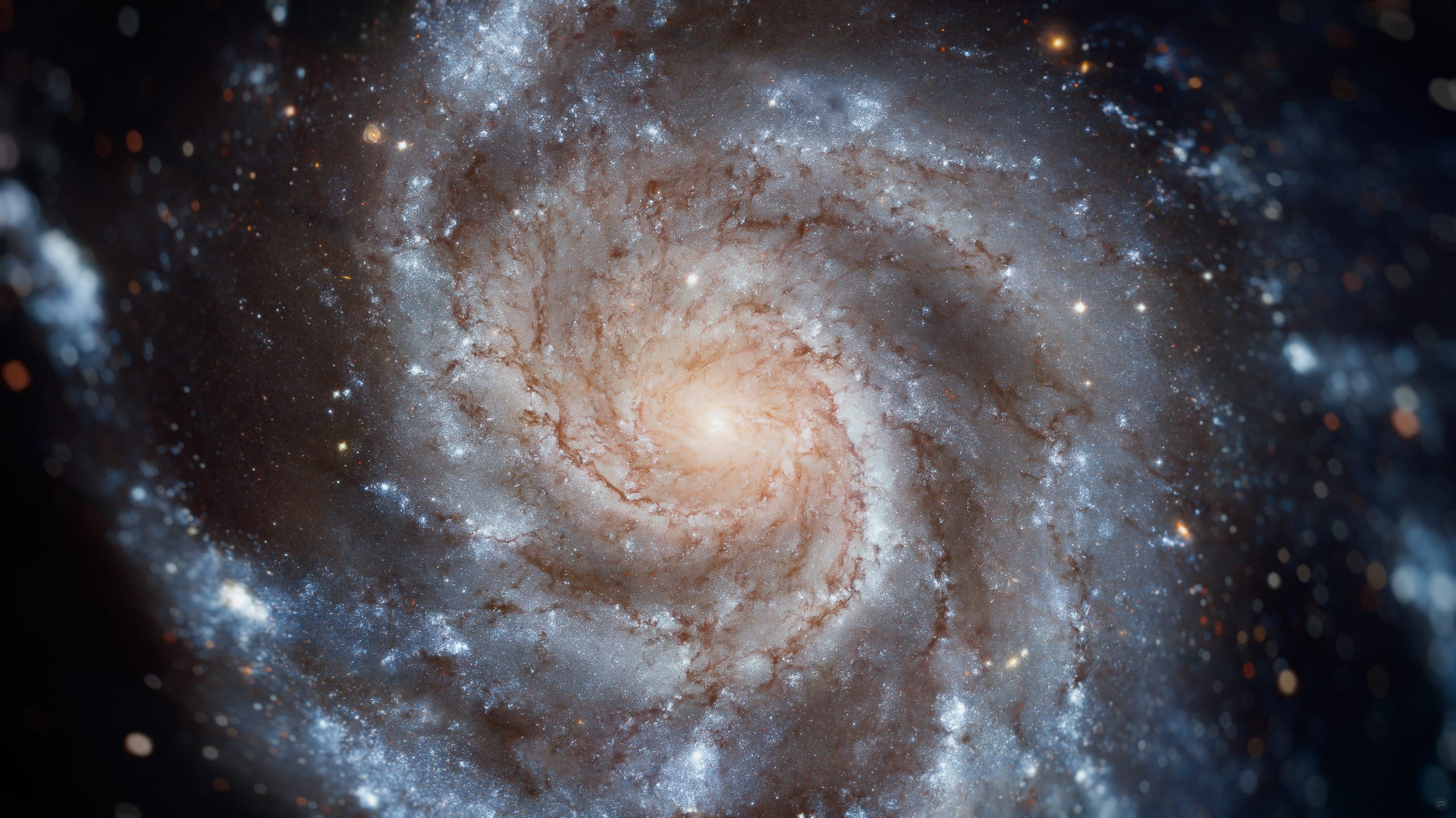
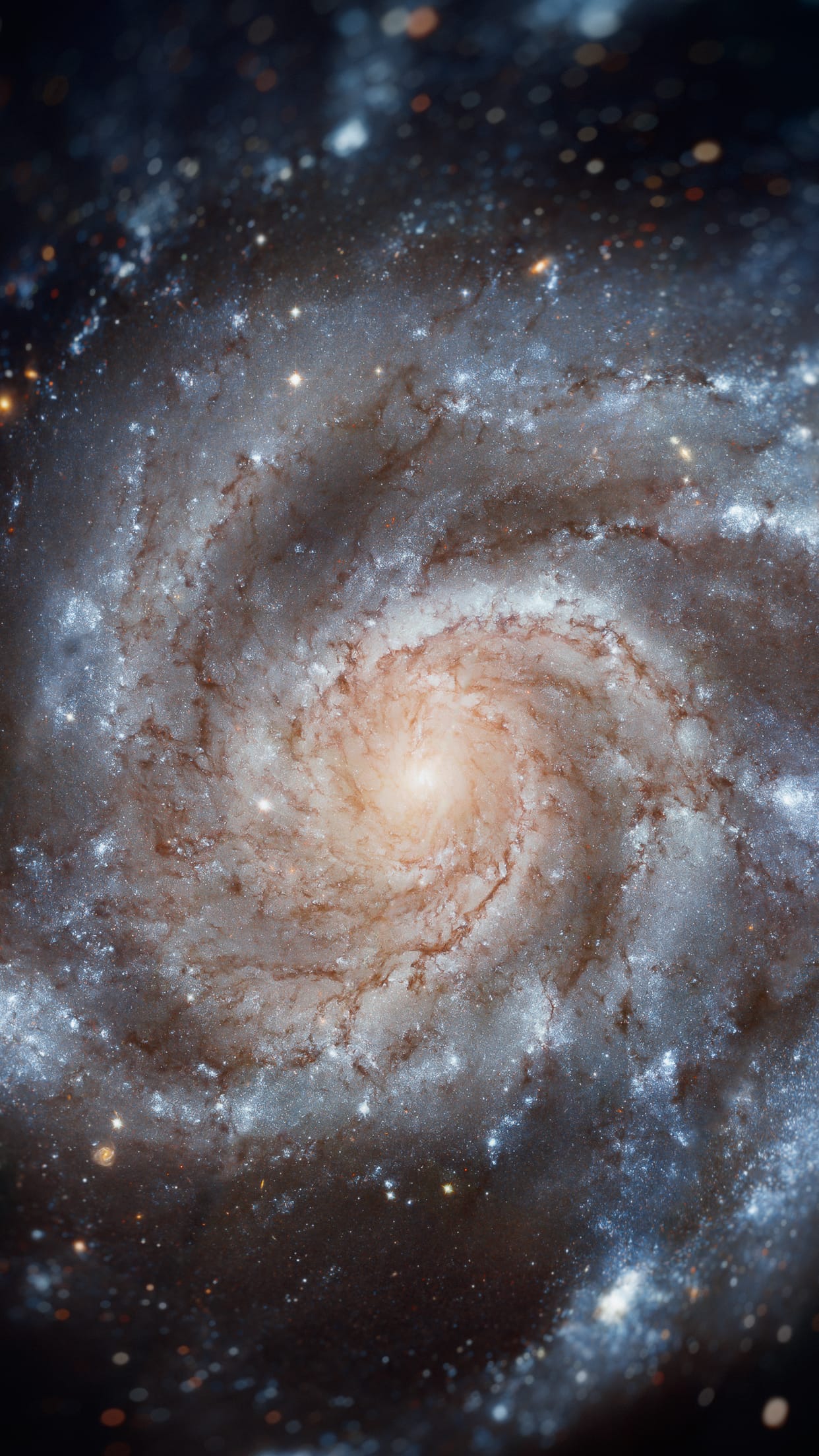
Hubble's sharpest view of the Orion Nebula.
Deep Space — Psiu Puxa Space Wallpapers
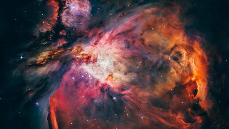
This dramatic image offers a peek inside a cavern of roiling dust and gas where thousands of stars are forming. The image, taken by the Advanced Camera for Surveys (ACS) aboard NASA/ESA Hubble Space Telescope, represents the sharpest view ever taken of this region, called the Orion Nebula. More than 3,000 stars of various sizes appear in this image. Some of them have never been seen in visible light. These stars reside in a dramatic dust-and-gas landscape of plateaus, mountains, and valleys that are reminiscent of the Grand Canyon.

The Orion Nebula is a picture book of star formation, from the massive, young stars that are shaping the nebula to the pillars of dense gas that may be the homes of budding stars. The bright central region is the home of the four heftiest stars in the nebula. The stars are called the Trapezium because they are arranged in a trapezoid pattern. Ultraviolet light unleashed by these stars is carving a cavity in the nebula and disrupting the growth of hundreds of smaller stars. Located near the Trapezium stars are stars still young enough to have disks of material encircling them. These disks are called protoplanetary disks or "proplyds" and are too small to see clearly in this image. The disks are the building blocks of solar systems.

The bright glow at upper left is from M43, a small region being shaped by a massive, young star's ultraviolet light. Astronomers call the region a miniature Orion Nebula because only one star is sculpting the landscape. The Orion Nebula has four such stars. Next to M43 are dense, dark pillars of dust and gas that point toward the Trapezium. These pillars are resisting erosion from the Trapezium's intense ultraviolet light. The glowing region on the right reveals arcs and bubbles formed when stellar winds - streams of charged particles ejected from the Trapezium stars - collide with material.

The faint red stars near the bottom are the myriad brown dwarfs that Hubble spied for the first time in the nebula in visible light. Sometimes called "failed stars," brown dwarfs are cool objects that are too small to be ordinary stars because they cannot sustain nuclear fusion in their cores the way our Sun does. The dark red column, below, left, shows an illuminated edge of the cavity wall.

The Orion Nebula is 1,500 light-years away, the nearest star-forming region to Earth. Astronomers used 520 Hubble images, taken in five colours, to make this picture. They also added ground-based photos to fill out the nebula. The ACS mosaic covers approximately the apparent angular size of the full moon.

The Orion observations were taken between 2004 and 2005.
Credit: NASA, ESA, M. Robberto ( Space Telescope Science Institute/ESA) and the Hubble Space Telescope Orion Treasury Project Team

#66 MARTIAN TERRAIN

Cones Formed by Hot Lava Running over Water or Ice.
Martian Terrain — Psiu Puxa Space Wallpapers
These cones are similar in size and shape to cones found in Iceland where hot lava has run over wet ground.

The heat from the lava boils the water which bursts through the lava flow. These steam-driven exploding bubbles of lava throw chunks of molten and solid lava into the air.

A long series of such explosions is needed to build up one of the large cones. The cones appear in chains because the surface of the lava flow was moving while the series of explosions were taking place. This is sort of like a miniature version of how the Hawaiian Island chain forms. The hot spot under Hawaii is fixed but the Earth's crust slides past it.

Written by: Lazslo Kestay

#65 MARTIAN TERRAIN

Light-Toned Deposits in Noctis Labyrinthus.
Martian Terrain — Psiu Puxa Space Wallpapers
CRISM observations of this region of the Noctis Labyrinthus formation have shown indications of iron-bearing sulfates and phyllosilicate (clay) minerals. (CRISM is another instrument on the Mars Reconnaissance Orbiter.)

HiRISE observations have revealed exposed layers which are possibly the sources of the signatures seen by CRISM. The layering, is visible in the lower part of the image. To the upper left one can see a dune field which covers other beds.

Written by: Nicolas Thomas

#64 DEEP SPACE

Pinwheel Galaxy.
Deep Space — Psiu Puxa Space Wallpapers
This new Hubble image reveals the gigantic Pinwheel galaxy, one of the best known examples of "grand design spirals", and its supergiant star-forming regions in unprecedented detail. The image is the largest and most detailed photo of a spiral galaxy ever taken with Hubble.

The Pinwheel Galaxy (also known as Messier 101, M101 or NGC 5457) is a face-on spiral galaxy distanced 21 million light-years (six megaparsecs) away in the constellation Ursa Major, first discovered by Pierre Méchain on March 27, 1781, and communicated to Charles Messier who verified its position for inclusion in the Messier Catalogue as one of its final entries.

Acknowledgements:
Project Investigators for the original Hubble data: K.D. Kuntz (GSFC), F. Bresolin (University of Hawaii), J. Trauger (JPL), J. Mould (NOAO), and Y.-H. Chu (University of Illinois, Urbana)
Image processing: Davide De Martin (ESA/Hubble)
CFHT image: Canada-France-Hawaii Telescope/J.-C. Cuillandre/Coelum
NOAO image: George Jacoby, Bruce Bohannan, Mark Hanna/NOAO/AURA/NSF

#63 MARTIAN TERRAIN

Sedimentary / Layering Processes.
Martian Terrain — Psiu Puxa Space Wallpapers
Layering and Faulting in Melas Chasma Layered Deposits.

#62 MARTIAN TERRAIN

Aeolian Processes.
Martian Terrain — Psiu Puxa Space Wallpapers
Dunes of sand-sized materials have been trapped on the floors of many Martian craters. This is one example, from a crater in Noachis Terra, west of the giant Hellas impact basin.

The dunes here are linear, thought to be due to shifting wind directions. In places, each dune is remarkably similar to adjacent dunes, including a reddish (or dust colored) band on northeast-facing slopes. Large angular boulders litter the floor between dunes.

The most extensive linear dune fields know in the Solar System are on Saturn's large moon Titan. Titan has a very different environment and composition, so at meter-scale resolution they probably are very different from Martian dunes.

Written by: Alfred McEwen

#61 MARTIAN TERRAIN

Dunes and Inverted Craters in Arabia Terra.
Martian Terrain — Psiu Puxa Space Wallpapers
This image shows dark sand dunes and inverted craters in the Arabia Terra region of Mars.

The sand is dark because it was probably derived from basalt, a black volcanic rock that is common on Mars. Unlike traditional craters that are depressions, those here stick up above the surrounding plains. Such "inverted topography" is found on Mars and Earth where erosion has stripped away surrounding topography.

In this case, the craters were filled with sediment. Subsequent erosion stripped away the terrain around the filled craters, leaving the inverted topography visible here.

Written by: Nathan Bridges
All original images are presented by:
547d825dd0db3b8058acab8d_nasa.png 547d828239b0bf7409a305d1_arizona.png 547d828cd0db3b8058acab91_esa.png 547d832bd0db3b8058acab97_hubble.png 547d83369e4d1e7609d4c35d_jpl.png