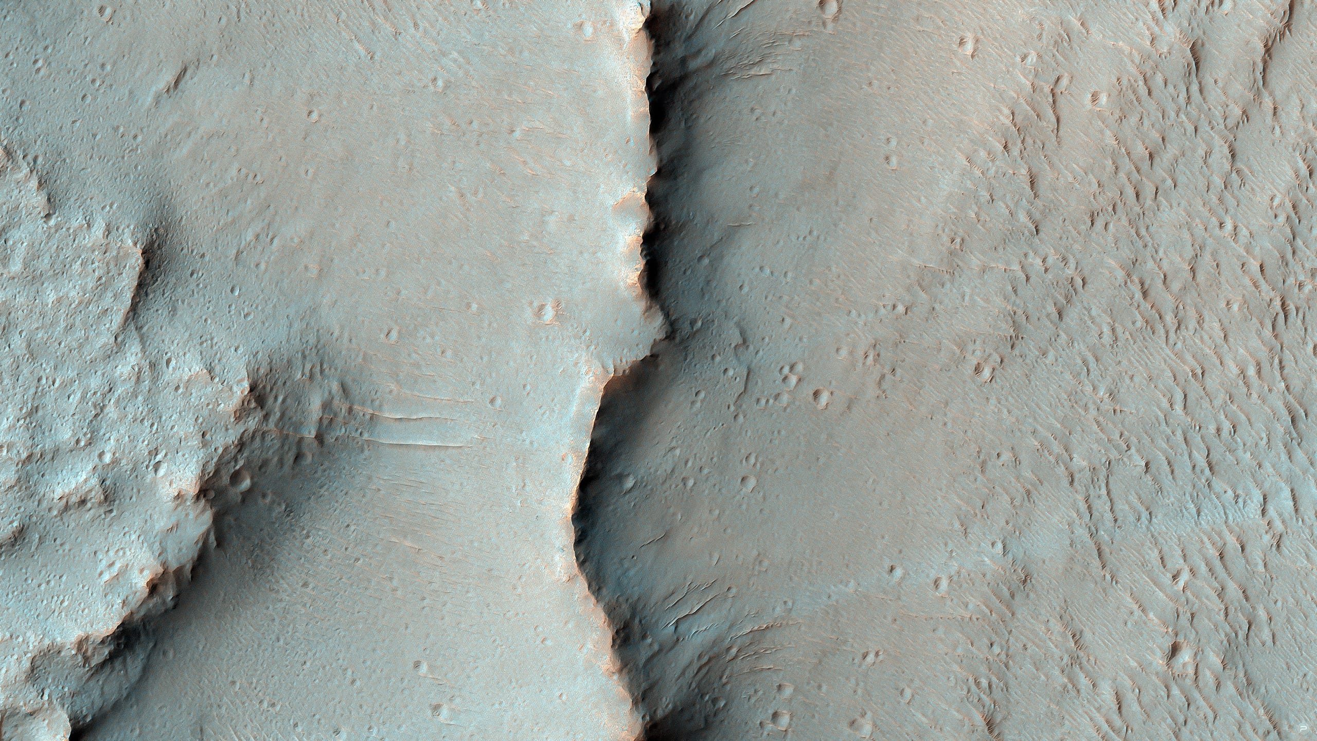
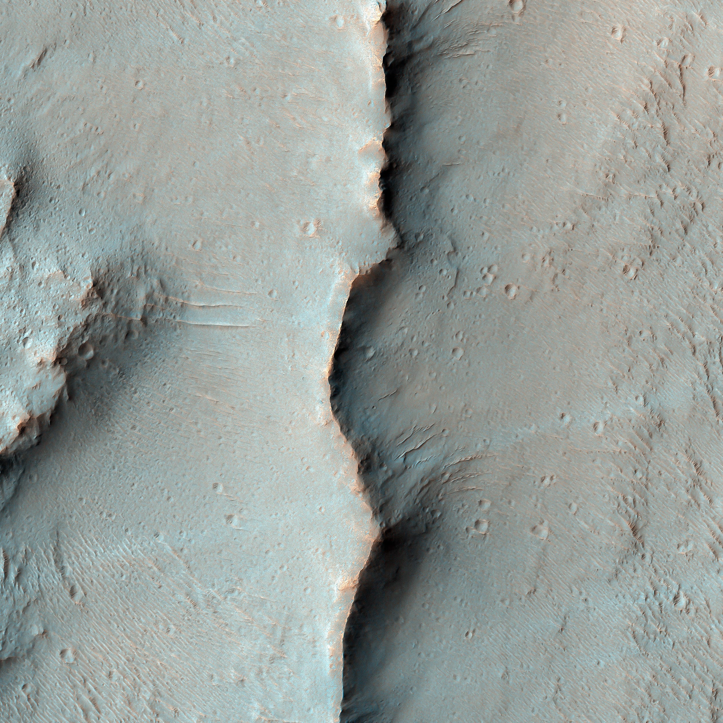
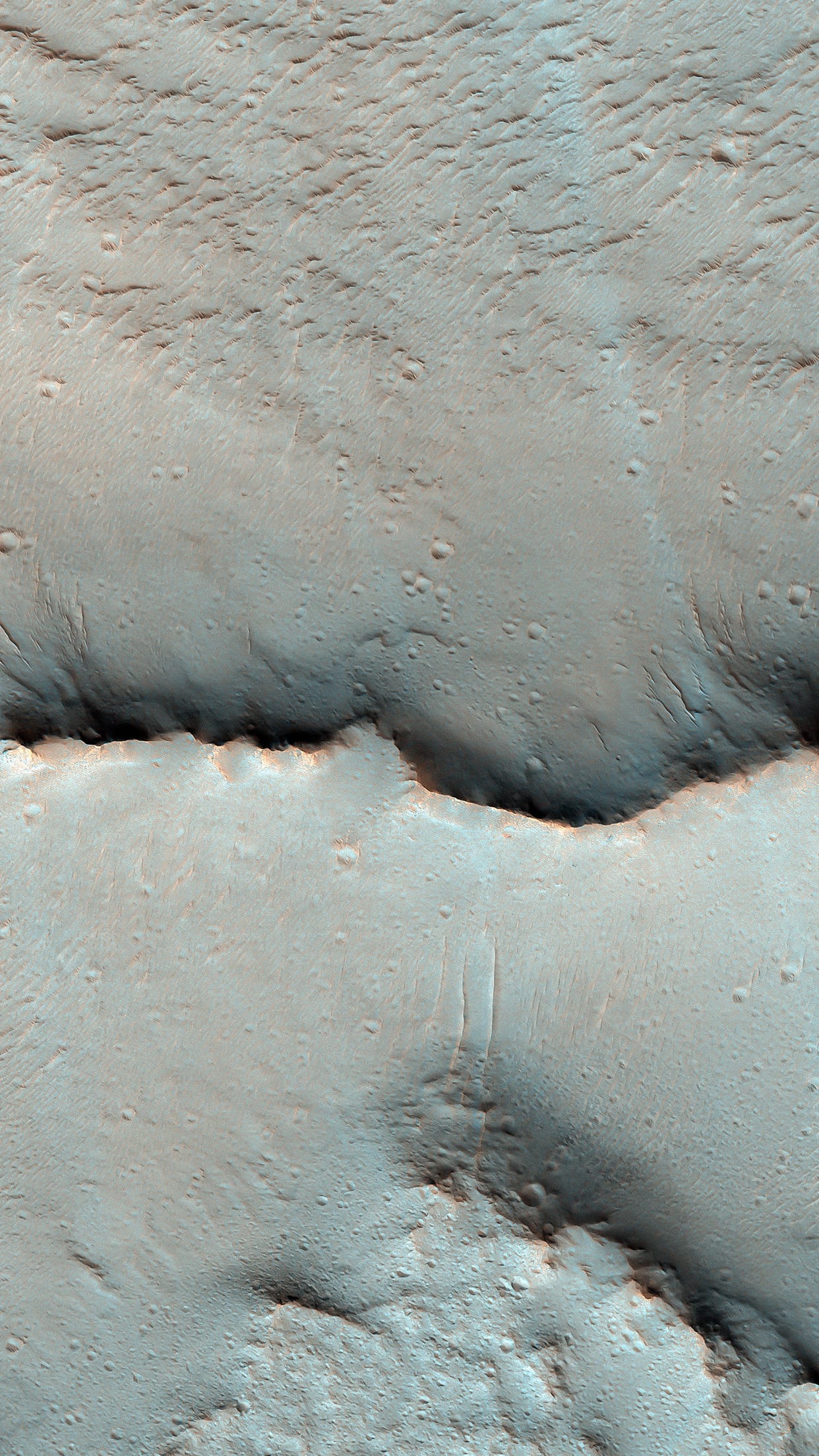
#60 MARTIAN TERRAIN

Sedimentary / Layering Processes.
Martian Terrain — Psiu Puxa Space Wallpapers
Samara Valles is one of the longest ancient valley systems on Mars. This system traverses over 1000 kilometers towards the northwest across the heavily cratered Southern highlands eroding into the gentle slopes of Terra Meridiani. The valley terminates in the Northern lowlands within the Chryse Basin where both Viking Lander 1 and Pathfinder are located.


Written by: Ginny Gulick

#59 MARTIAN TERRAIN

Exposed Light Material in Upland Region in Aureum Chaos.
Martian Terrain — Psiu Puxa Space Wallpapers
The plateau visible in this image is located within Aureum Chaos. Chaotic terrains on Mars are blocky, fractured regions of flat-topped hills, plateaus, plains, and depressions thought to have formed by the collapse of the heavily cratered uplands.

Large outflow channels appear to emerge from Aureum Chaos and other chaotic terrains leading researchers to posit that these large collapse regions were formed by the catastrophic release of ground water. Aureum Chaos is located just to the northeast of Valles Marineris adjacent to Margaritifer Terra, and it has a diameter of approximately 368 kilometers.

The steep-sided plateau in this image has a sharp, undulating surface possibly etched out and eroded by persistent winds. These same winds may well have transported the resulting sediment to the surrounding plains helping to form the dunes below. The plateau slopes are steep and consist of a series of parallel bright, more resistant cliff forming layers and darker, less resistant slope material. A good way to see the differences in color between the plateau's bright layered deposits and the surrounding area is to look at some of the blocks that have fallen off the cliff onto the the dark sands below.

By studying areas of Mars such as this one, researchers hope to understand how the chaos regions formed and how their formation related to the release of ground water to form the outflow channels, if indeed the two are connected in this way.

Written by: Shawn Hart and Ginny Gulick

#58 deep space

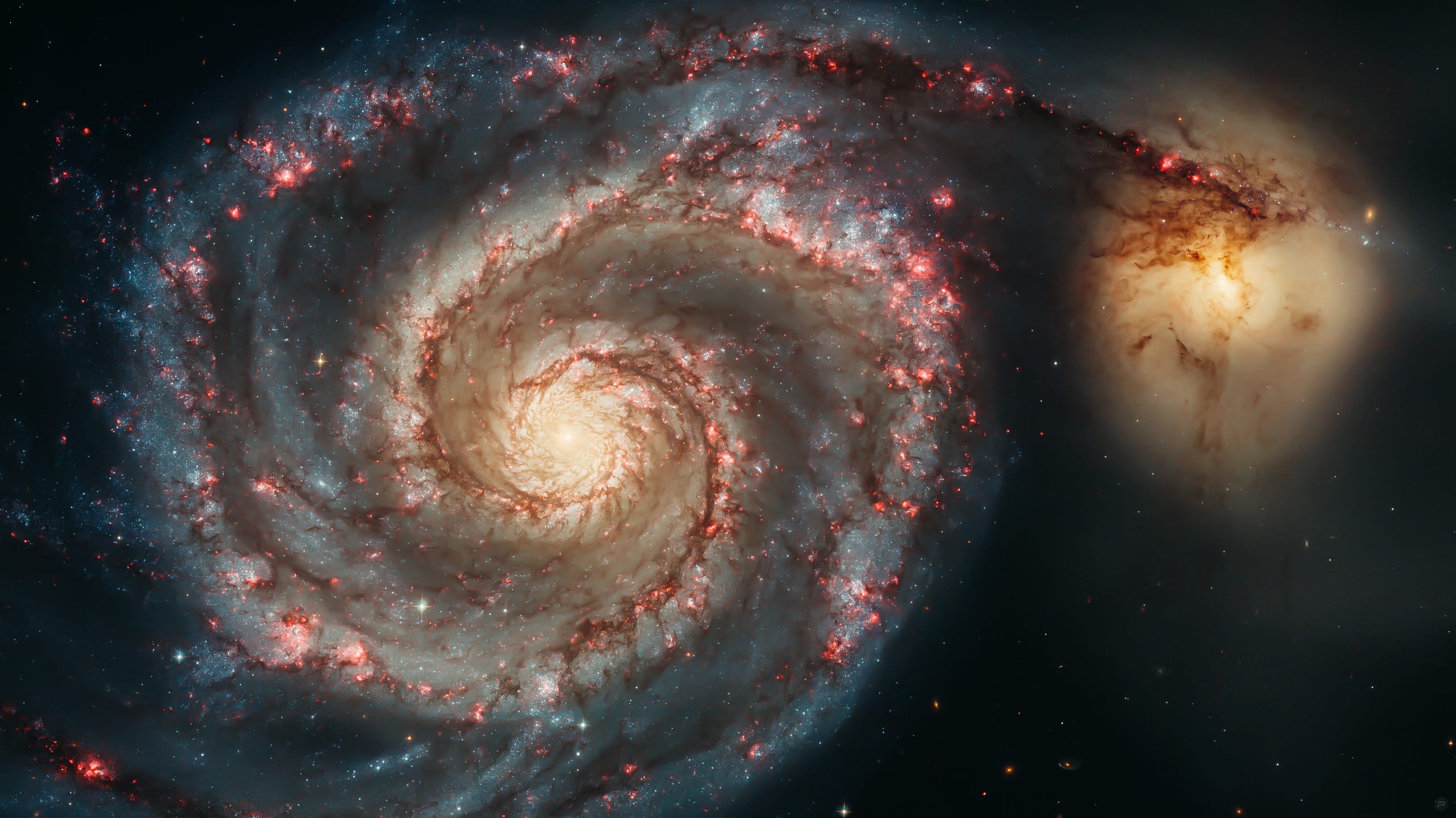
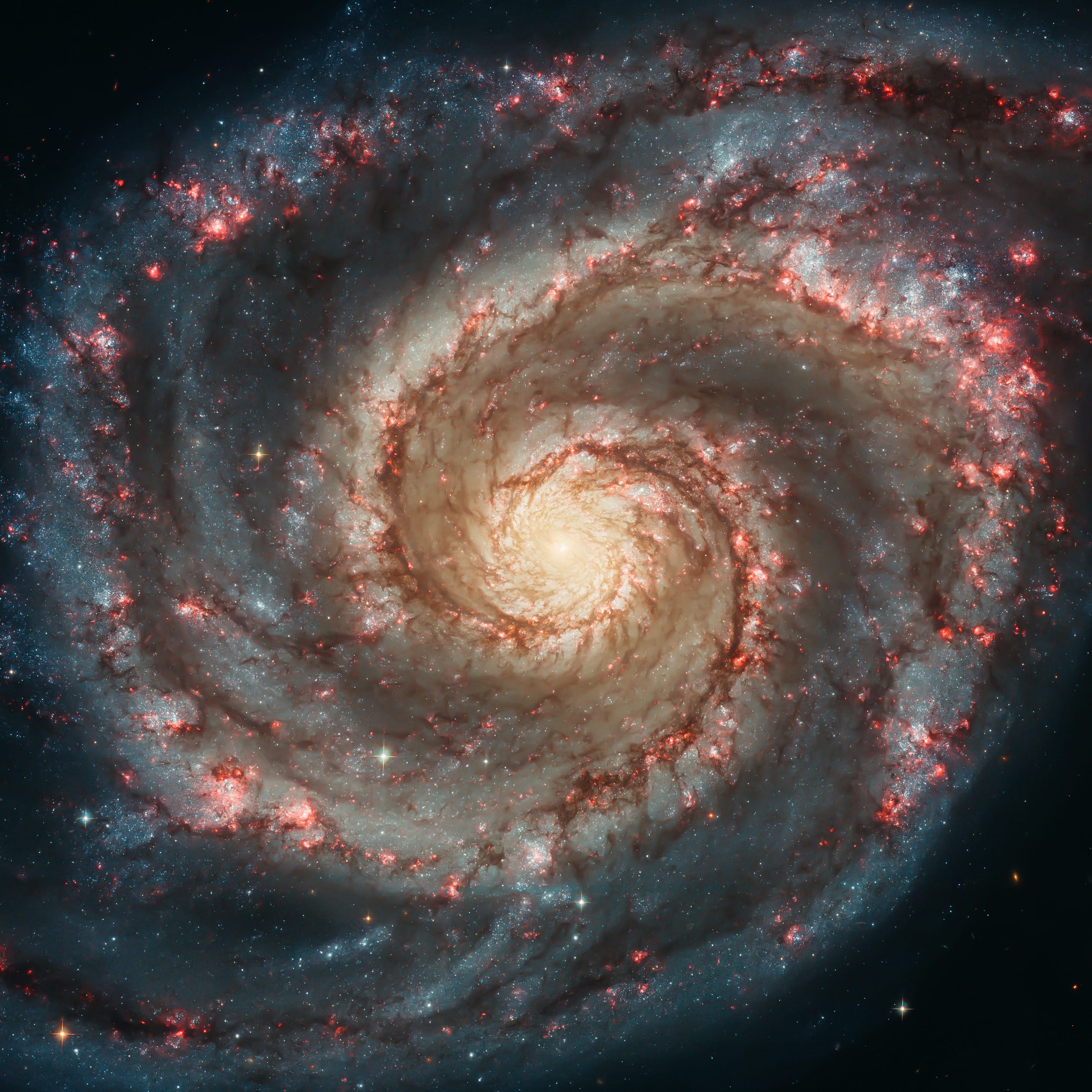
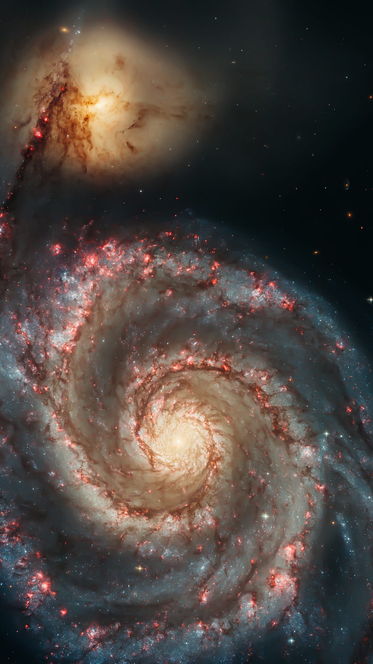
Out of this whirl: The Whirlpool Galaxy (M51) and companion galaxy.
Deep Space — Psiu Puxa Space Wallpapers
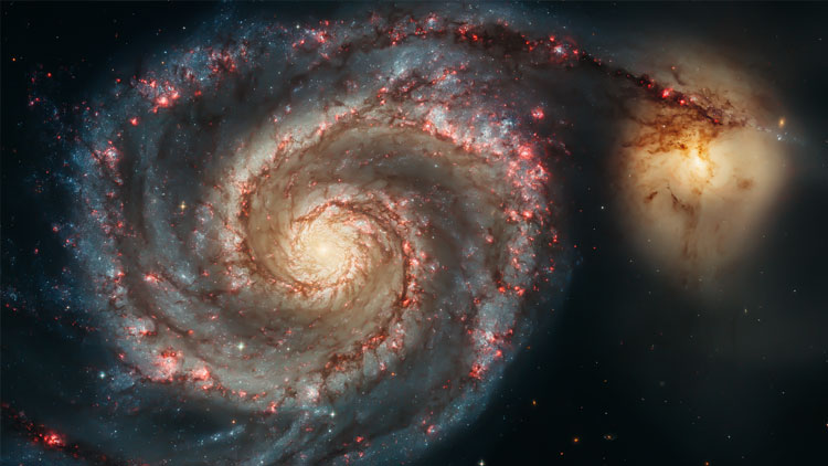
The graceful, winding arms of the majestic spiral galaxy M51 (NGC 5194) appear like a grand spiral staircase sweeping through space. They are actually long lanes of stars and gas laced with dust.

This sharpest-ever image, taken in January 2005 with the Advanced Camera for Surveys aboard the NASA/ESA Hubble Space Telescope, illustrates a spiral galaxy's grand design, from its curving spiral arms, where young stars reside, to its yellowish central core, a home of older stars. The galaxy is nicknamed the Whirlpool because of its swirling structure.

The Whirlpool's most striking feature is its two curving arms, a hallmark of so-called grand-design spiral galaxies. Many spiral galaxies possess numerous, loosely shaped arms that make their spiral structure less pronounced. These arms serve an important purpose in spiral galaxies. They are star-formation factories, compressing hydrogen gas and creating clusters of new stars. In the Whirlpool, the assembly line begins with the dark clouds of gas on the inner edge, then moves to bright pink star-forming regions, and ends with the brilliant blue star clusters along the outer edge.

Some astronomers believe that the Whirlpool's arms are so prominent because of the effects of a close encounter with NGC 5195, the small, yellowish galaxy at the outermost tip of one of the Whirlpool's arms. At first glance, the compact galaxy appears to be tugging on the arm. Hubble's clear view, however, shows that NGC 5195 is passing behind the Whirlpool. The small galaxy has been gliding past the Whirlpool for hundreds of millions of years.

As NGC 5195 drifts by, its gravitational muscle pumps up waves within the Whirlpool's pancake-shaped disk. The waves are like ripples in a pond generated when a rock is thrown in the water. When the waves pass through orbiting gas clouds within the disk, they squeeze the gaseous material along each arm's inner edge. The dark dusty material looks like gathering storm clouds. These dense clouds collapse, creating a wake of star birth, as seen in the bright pink star-forming regions. The largest stars eventually sweep away the dusty cocoons with a torrent of radiation, hurricane-like stellar winds, and shock waves from supernova blasts. Bright blue star clusters emerge from the mayhem, illuminating the Whirlpool's arms like city streetlights.

The Whirlpool is one of astronomy's galactic darlings. Located approximately 25 million light-years away in the constellation Canes Venatici (the Hunting Dogs), the Whirlpool's beautiful face-on view and closeness to Earth allow astronomers to study a classic spiral galaxy's structure and star-forming processes.

Credit: NASA, ESA, S. Beckwith (STScI), and The Hubble Heritage Team STScI/AURA)

#57 MARTIAN TERRAIN

Geologic Contacts / Stratigraphy.
Martian Terrain — Psiu Puxa Space Wallpapers
Possible Cyclic Bedding in Arabia Terra.

#56 MARTIAN TERRAIN

Cerberus Fossae East of the Head of Athabasca Valles.
Martian Terrain — Psiu Puxa Space Wallpapers
This image shows part of Cerberus Fossae, a long system of extensional (normal) faults arranged in trough-bounding (graben-bounding) pairs. Cerberus Fossae served as the source of a large volcanic eruption that draped Athabasca Valles in lava.

Large boulders that have been dislodged from the graben walls are visible on the floor of Cerberus Fossae. The image shows an example of an approximately 6 meter (20 feet) boulder that left a distinct track as it moved downhill. Although this track is quite clear, ripples inside the track are discernable, indicating that enough time has passed for wind activity to rework loose material into the form of ripples. With close examination of this observation, one can see many boulder tracks, some with ripples and some without ripples.

Written by: Anjani Polit

#55 DEEP SPACE

The Eagle has risen: Stellar spire in the Eagle Nebula.
Deep Space — Psiu Puxa Space Wallpapers
Appearing like a winged fairy-tale creature poised on a pedestal, this object is actually a billowing tower of cold gas and dust rising from a stellar nursery called the Eagle Nebula. The soaring tower is 9.5 light-years or about 90 trillion kilometres high, about twice the distance from our Sun to the next nearest star.

Stars in the Eagle Nebula are born in clouds of cold hydrogen gas that reside in chaotic neighbourhoods, where energy from young stars sculpts fantasy-like landscapes in the gas. The tower may be a giant incubator for those newborn stars. A torrent of ultraviolet light from a band of massive, hot, young stars [off the top of the image] is eroding the pillar.

The starlight also is responsible for illuminating the tower's rough surface. Ghostly streamers of gas can be seen boiling off this surface, creating the haze around the structure and highlighting its three-dimensional shape. The column is silhouetted against the background glow of more distant gas.

The edge of the dark hydrogen cloud at the top of the tower is resisting erosion, in a manner similar to that of brush among a field of prairie grass that is being swept up by fire. The fire quickly burns the grass but slows down when it encounters the dense brush. In this celestial case, thick clouds of hydrogen gas and dust have survived longer than their surroundings in the face of a blast of ultraviolet light from the hot, young stars.

Inside the gaseous tower, stars may be forming. Some of those stars may have been created by dense gas collapsing under gravity. Other stars may be forming due to pressure from gas that has been heated by the neighbouring hot stars.

The first wave of stars may have started forming before the massive star cluster began venting its scorching light. The star birth may have begun when denser regions of cold gas within the tower started collapsing under their own weight to make stars.

The bumps and fingers of material in the centre of the tower are examples of these stellar birthing areas. These regions may look small but they are roughly the size of our solar system. The fledgling stars continued to grow as they fed off the surrounding gas cloud. They abruptly stopped growing when light from the star cluster uncovered their gaseous cradles, separating them from their gas supply.

Ironically, the young cluster's intense starlight may be inducing star formation in some regions of the tower. Examples can be seen in the large, glowing clumps and finger-shaped protrusions at the top of the structure. The stars may be heating the gas at the top of the tower and creating a shock front, as seen by the bright rim of material tracing the edge of the nebula at top, left. As the heated gas expands, it acts like a battering ram, pushing against the darker cold gas. The intense pressure compresses the gas, making it easier for stars to form. This scenario may continue as the shock front moves slowly down the tower.

The dominant colours in the image were produced by gas energized by the star cluster's powerful ultraviolet light. The blue colour at the top is from glowing oxygen. The red colon in the lower region is from glowing hydrogen.

The Eagle Nebula image was taken in November 2004 with the Advanced Camera for Surveys aboard the NASA/ESA Hubble Space Telescope.
Credit: NASA, ESA, and The Hubble Heritage Team STScI/AURA)

#54 MARTIAN TERRAIN

Tithonium Chasma.
Martian Terrain — Psiu Puxa Space Wallpapers
This complicated landscape of craters, slopes, and boulders is in an area called Tithonium Chasma, a large trough that is itself a part of the more well-known canyon system Valles Marineris.

Scientists are interested in imaging canyons such as these because they provide a view "under" the surrounding Martian surface to potentially older material beneath (similar to the Grand Canyon on Earth).

Evidence from the CRISM instrument, a spectrometer also aboard Mars Reconnaissance Orbiter, suggests sulfates and iron oxides exist in this general region, in the form of layered deposits. (Murchie, S. et al. 2009. A synthesis of Martian aqueous mineralogy after 1 Mars year of observations from the Mars Reconnaissance Orbiter. Journal of Geophysical Research: 114.) It is unknown how far these deposits may extend beneath the surface.

MYTHOLOGY
In Greek mythology, Tithonos was the son of Troy's King Laomedon. The goddess of the dawn, Eos, fell in love with him and kidnapped him, asking Zeus to make him immortal, but forgetting to ask to make him forever young. When Tithonos reached a very advanced age, only his voice was still young, and Eos no longer wanted him, so Zeus, to save Tithonos from torment, turned him into an insect that would never stop singing: the cicada.


Written by: Kristin Block

#53 MARTIAN TERRAIN

Opportunity’s Goal: Northwest Endeavour Crater Rim.
Martian Terrain — Psiu Puxa Space Wallpapers
This observation is of the northwest rim of Endeavour Crater, which is the Opportunity rover's immediate driving goal on Mars. The subimage shows the whitish sulfate sedimentary rocks peeking beneath the dark sand that Opportunity has been driving on, layered material deposited around the crater rim, and the reddish material of the crater rim.

CRISM spectral information indicates a number of different hydrated sulfates in the whitish material beneath the sand and phyllosilicates, or water bearing clay minerals, in the reddish rim. The phyllosilicates are believed to have formed prior to the sulfates, during a wet period that was near neutral acidity (and not like the very acid conditions that formed the sulfates).

Phyllosilicates are the focus of all of the landing sites being considered for the next rover, Mars Science Laboratory, scheduled to launch in late 2011.

Written by: Matt Golombek

#52 MARTIAN TERRAIN

Which Crater Came First?
Martian Terrain — Psiu Puxa Space Wallpapers
This image shows two craters, both approximately the same diameter (not quite 3 kilometers, or about 1.8 miles), but quite different in appearance otherwise.

The slightly smaller crater to the south seems to have a sharper rim and steeper sides than its partner to the north, which also appears to contain more small craters inside it and along its rim. The interior of the northern crater, in particular its south-facing wall, appears to have a similar texture to the ejecta around the southern crater. 

Although it would require a digital terrain model and more analysis to be certain, in the anaglyph it appears that the southern crater has a higher rim and a deeper center than the northern crater. All these signs point to the northern crater being quite a bit older than the southern crater, rather than the two craters forming in the same impact event. 

Compare the similarity of those two craters with the disparate appearance of the ones in this image.

Written by: Nicole Baugh

#51 MARTIAN TERRAIN

Landscape Evolution.
Martian Terrain — Psiu Puxa Space Wallpapers
This image shows a series of long meandering ridges on the floor of a large ancient crater. Ridges such as these can be indicative of a number of geologic processes and tells us a story of the history of this region of Mars.

In some cases magma (molten rock) below the surface may fill an existing and somewhat vertical tectonic fracture, even pushing the fracture open in the process. As the magma cools, it solidifies into a tabular rock mass. This resulting cooled volcanic rock is called a "dike."

The new rock is often harder and more resistant to erosion than the surrounding country rock (the fractured rock of the original landscape). Later the entire region might have experience erosion from wind or water, removing weaker rocks and soils and leaving stronger rock outcrops standing. As the landscape is stripped away the harder volcanic rock remains standing as a long wall or ridge.

Alternatively glaciers often contain internal rivers from melting ice that flow along their base where the ice meets the ground. These subglacial rivers can carry enormous amounts of rocks and soil sediments, depositing them along their length. When the glacier retreats it leave behind a narrow ridge of river-bed sediments that stands above the surrounding surface. In this case the ridge is called an "esker."

A river flowing along the surface in the absence of a glacier can produce erosion and deposition along the river bed. It can also chemically alter the river bottom, through deposition of minerals and salts that cement the soils and rocks. Later, after the river has dried up, erosion of the landscape can leave the altered river bed standing above the surrounding terrain, called an "inverted channel."

So what happened in Peta Crater? Analysis of this image might reveal characteristics, such as layers along the ridge walls that would indicate the ridge was deposited by flowing water. Rocks and boulders might be found eroding from the ridge, their size and shape offering clues to the strength of the ridge material; fractured and angular solid rock from a dike or loosely bound rounded boulders tumbled along a river bed.

Written by: Mike Mellon
All original images are presented by:
547d825dd0db3b8058acab8d_nasa.png 547d828239b0bf7409a305d1_arizona.png 547d828cd0db3b8058acab91_esa.png 547d832bd0db3b8058acab97_hubble.png 547d83369e4d1e7609d4c35d_jpl.png